his page updated reflects the RF environment after the completion of phase 4 in NYC.
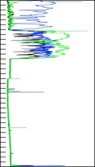
The data in this graph represents the NYC RF environment on February 9th 2020.
The data was collected from three spectrum scans from outside locations in Manhattan, one at Tribeca park near One WTC, the Second near MSG, and the third on the east side near Trump World Tower. You can use these three scans to determine the television stations to avoid in Manhattan dependent on you location.
CSV files of the data used to make the plot below are available in the download section of this site.
Black - South WTC
Green - West 9th AVE & 35th
Blue - East 1st AVE & 47th
Ch.4 66-72
76-82
ADA Devices
Ch.5 76-82
Ch.6 82=88
WNZY FM 87.7 MHz
Ch.8 180-188
WNJB
Ch.9 188-192
Ch.12 204-210
WNET Loacation
By 13JUL2020